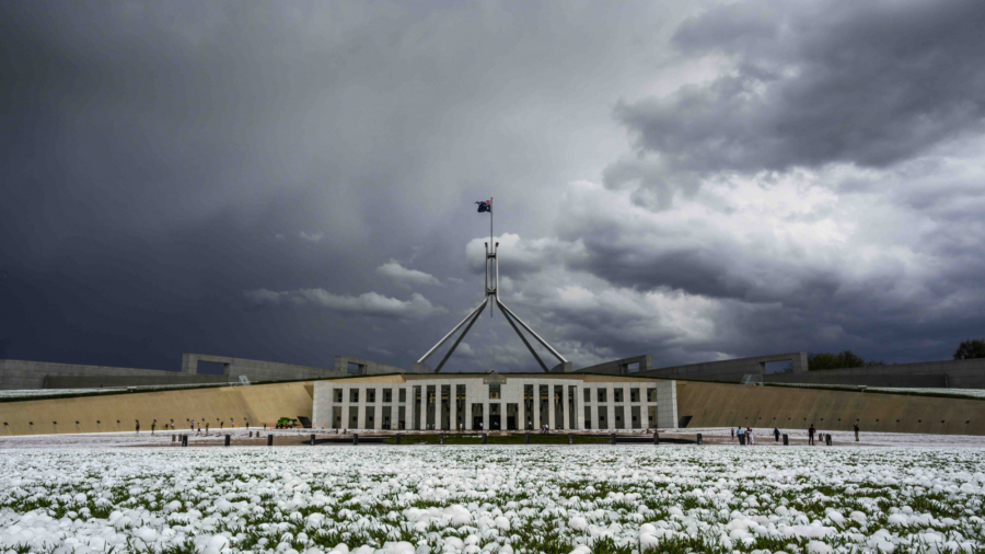
A fierce hailstorm has pelted Canberra with stones the size of golf balls inflicting severe damage across Australia’s capital city.
At 2:50 p.m., the ACT Emergency Services Agency had received more than 1200 calls for help after Monday afternoon’s 15-minute storm.
The State Emergency Service, Fire and Rescue and Rural Fire Service are responding to hail and roof damage, electrical threats and localised flooding.
ACT Ambulance Service is attending to two people with minor injuries sustained during the storm.
An intelligence-gathering helicopter is flying over Canberra conducting a damage assessment.
Power has been restored to most of the 1,000 homes which suffered outages, according to the territory’s gas and electricity distributor.
About 170 customers are still without power.
The storm thrashed Parliament House, which looked like snow had fallen, but it appears the building escaped serious damage.

The worst-affected areas are Belconnen in Canberra’s north, the city centre and the inner south.
Hundreds of windscreens were smashed at Old Parliament House, the Australian National University and other parts of the city.
Reports of 4-5cm hail in Canberra with a severe storm earlier this afternoon. Further storms are possible. Keep up to date with warnings here: https://t.co/WwMKAwqVNM and ensure you are storm ready by following these handy tips: https://t.co/dOCvpT15v5 pic.twitter.com/JnXGVePW2U
— Bureau of Meteorology Australian Capital Territory (@BOM_ACT) January 20, 2020
Old Parliament House closed to visitors soon after the storm struck.
Canberra tour guide Tim the Yowie Man tweeted a picture of the National Sound and Film Archive’s roof being punctured “like bullets.”
It remained open to visitors on Monday despite the damage. “Our collection is safe,” a spokeswoman said.
However, the National Archives of Australia was closed due to damage.
A wind gust of 117 kilometers per hour (72 miles per hour) was recorded at Canberra Airport where 2.4 millimeters of rain fell. Tuggeranong in the ACT’s south got 5mm in 10 minutes to take its total to 9 millimeters.
Animals were injured during the storm, with parliament staff looking after a bloodied crow that copped a hailstone to its head.
The wild weather is the latest twist in Canberra’s bizarre summer after the city was choked with thick bushfire smoke over the past month.
Storm Warnings
The Bureau of Meteorology on Monday issued a severe thunderstorm warning for parts of 13 districts in NSW, incorporating an area stretching from Tamworth to the NSW-Victoria border and as far west as Narrandera.
Greater Sydney, Gosford, Newcastle and other regional centres including Wagga Wagga, Albury and Griffith would likely be hit by destructive winds, giant hail stones and rainfall on Monday afternoon.
The bureau said the low-pressure system that prompted the thunderstorm warning would move east to the Tasman Sea on Monday night.
The NSW State Emergency Service warns the storms are expected to cause “havoc” for peak hour commuters
Emergency Services minister David Elliott asked drivers to take it easy on the state’s roads.
“Make sure you make safe decisions and take the time to plan your trip, check for road closures and traffic conditions before you get on the road,” Elliott said in a statement on Monday.
“Run-off from rainfall in fire affected areas may behave differently and be more rapid resulting in flash flooding which may also contain debris such as ash, soil, trees and rocks,” continued Elliott.
SES assistant commissioner Paul Bailey asked the public to prepare for wet weather.
“I’m urging people to ask themselves the questions – what would you do with your pets, your car or loose outdoor furniture if a storm was to hit?” Bailey said in a statement.
Dust Storms
On Sunday, damaging winds from thunderstorms whipped up dust storms that turned daytime into night across central NSW.
Videos posted to social media showed dust storms descending on Dubbo and nearby towns that were so thick they blocked out the sun.
A gust of 94 kilometers per hour was recorded at Parkes about 6:30 p.m., while a gust of 107 kilometers per hour was recorded at Dubbo about 7:45 p.m., the bureau said.
Many towns on the mid-north coast and in the northern rivers region received between 100 and 180 millimeters from 9 a.m. to 10:30 p.m. on Sunday.
Downpours have provided relief for parts of drought-stricken NSW, and helped firefighters slow the spread of bushfires and build containment lines ahead of increased fire danger mid-week.
BOM forecaster Gabrielle Woodhouse told reporters on Monday that fire-affected areas could experience quick runoff, flash flooding, and roadways covered by ash and debris.
“Due to the fire and drought conditions, quite a lot of the vegetation is weakened and this means that trees and trees’ branches are going to be much more likely to come down due to wind gust or a bit of heavy hail,” Woodhouse said.
Winds will shift and come more from the north and west mid-week, bringing drier and warmer air—and higher fire danger—on Wednesday and Thursday.
But rain will return on Friday and the weekend.
By Matt Coughlan and Heather McNab


