


Video footage posted on Nov. 30, shows the aftermath of a strong 7.0 magnitude earthquake that struck near Anchorage, Alaska.
Scott Marsteller uploaded the video of the buckled road. A car is seen on an island of pavement left by the quake.
The Tsunami Warning Center issued a tsunami warning for all of Cook Inlet following an aftershock, according to the National Weather Service. Several significant aftershocks struck the region following the 7.0 magnitude quake.
Alaska station KTUU reported that a possible landslide was triggered on the Seward Highway by McHugh Creek.
The Anchorage School District said it’s still accessing damage done by the quake, saying, “When you feel it is safe to pick up your children at your school, please do so.”
Kirstin Olmstead with UAA said its Anchorage campus and campus in Chugiak-Eagle River are both closed. “Please do not come to campus,” UAA said in an email, as reported by KTUU.
The Anchorage Police Department said it is operational following the quake, but it told the public to call 911 only for emergencies.
There were reports of damage done to a high school in Anchorage (as seen below).
“Our officers have been dispatched throughout the area and are handling multiple situations. We are working with our public safety partners to keep you safe. For parents, we are working with our partners at the Anchorage School District to check on your children and make sure they are safe,” the department said in a statement. “There is major infrastructure damage across Anchorage. Many homes and buildings are damaged. Many roads and bridges are closed. Stay off the roads if you don’t need to drive. Seek a safe shelter. Check on your surroundings and loved ones,” it added.
Reporters at KTVA spoke of falling window panes at the station’s building.
“The structure of the roof just collapsed,” a worker told CNN. “We can’t even get into our studio right now. There were computers flying, cameras toppling over.”
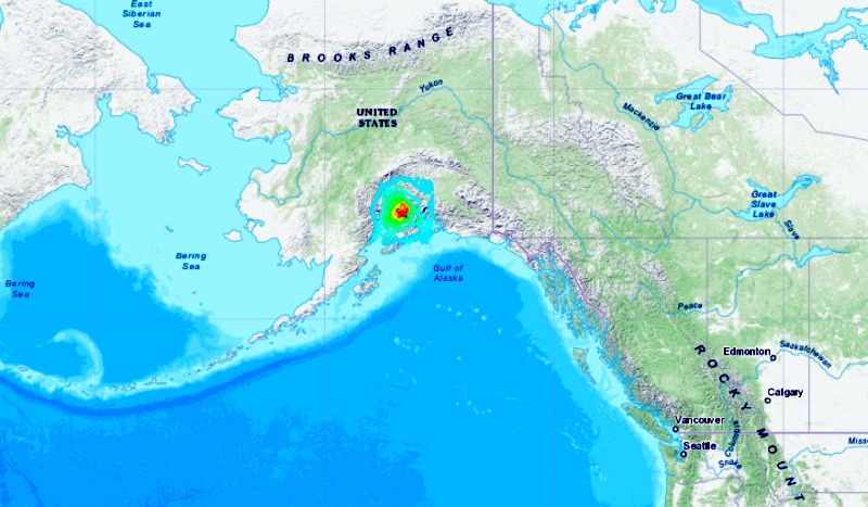
The initial reading of the quake by the U.S. Geological Survey said it registered as a 6.6 on the Richter scale. It has since been upgraded to a 7.0. The strongest aftershock was a 5.8 on the scale, the agency reported.
A tsunami warning was issued for the southern Alaska coastal areas of Cook’s Inlet and part of the Kenai Peninsula. Kodiak police on Kodiak Island warned people in the city of 6,100 to “evacuate to higher ground immediately” because of “wave estimated 10 minutes,” according to The Associated Press.
“It was anarchy,” said one local man to AP of the quake. “There’s no pictures left on the walls, there’s no power, there’s no fish tank left. Everything that’s not tied down is broke.”
On March 27, 1964, Alaska was hit by a magnitude 9.2 earthquake, the strongest recorded in U.S. history, centered about 75 miles east of Anchorage. The quake, which lasted about 4 and a half minutes, and the tsunami it triggered claimed about 130 lives.
Located on the Pacific “Ring of Fire,” Alaska is known to be particularly earthquake-prone.
The Associated Press contributed to this report.
From The Epoch Times